Model Details
Summary
The InVEST Coastal Vulnerability Model produces a qualitative estimate of such exposure in terms of a vulnerability index, which differentiates areas with relatively high or low exposure to erosion and inundation during storms (source). Urban coastal ecosystems are especially important due to the large populations these limited ecosystems serve (source). The purpose of this part is mainly to map coastal vulnerability and explore the role of sea level rise (SLR) and natural habitats played in influencing the relative exposure to coastal hazard.
from InVEST Documentation
Data needs
Before running the InVEST Coastal Vulnerability Model, check the key model input here.
How to run the model?
Model output
Layout
InVEST Coastal Vulnerability Model outputs have the following layout:
.
│  coastal_exposure.csv
│  coastal_exposure.gpkg
│  InVEST-natcap.invest.coastal_vulnerability-log-2023-01-27--21_22_44.txt
│
└─intermediate
    │  intermediate_exposure.csv
    │  intermediate_exposure.gpkg
    │
    ├─geomorphology
    │      geomorph.pickle
    │      geomorphology_projected.gpkg
    │      shore_points_missing_geomorphology.gpkg
    │
    ├─habitats
    │      Coral.pickle
    │      habitat_protection.csv
    │      Mangrove.pickle
    │      Seagrass.pickle
    │
    ├─population
    │      clipped_projected_pop.tif
    │      population.pickle
    │      Singpopulation_clipped.tif
    │
    ├─relief
    │      clipped_projected_dem.tif
    │      positive_dem.tif
    │      relief.pickle
    │      singdem1_clipped.tif
    │
    ├─sealevelrise
    ├─shore_points
    │      clipped_projected_landmass.gpkg
    │      landmass_line_index.pickle
    │      landmass_line_rtree.dat
    │      landmass_line_rtree.idx
    │      landmass_polygon.pickle
    │      shore_points.gpkg
    │      tmp_clipped_landmass.gpkg
    │
    ├─surge
    │      surge.pickle
    │
    ├─wind_wave
    │      clipped_projected_bathy.tif
    │      fetch_points.gpkg
    │      fetch_rays.gpkg
    │      gebco_2022_n1.5_s1.0_w103.0_e104.0_clipped.tif
    │      negative_bathymetry.tif
    │      wave.pickle
    │      wave_energies.gpkg
    │      wind.pickle
    │      wwiii_shore_points.gpkg
    │
    └─_taskgraph_working_dir
            taskgraph_data.db
Structure rundown
| Folder | File name(s) | Explanation |
|---|---|---|
| ./ | coastal_exposure.gpkg | This point vector file contains the final outputs of the model. The points are created based on the input model resolution, landmass, and area of interest |
| ./ | coastal_exposure.csv | This is an identical copy of the attribute table of coastal_exposure.gpkg provided in csv format for convenience |
| ./ | *.txt | The txt file lists the parameter values and output messages for that run and will be named according to the service, the date and time |
note
Only key outputs are listed in the above table.
As reflected by its name, files in the /intermediate folder are intermediate output.
If you want to learn more on these output, you can refer to this link.
Results visualization
| Relative exposure to coastal hazard (no habitats, no SLR) | 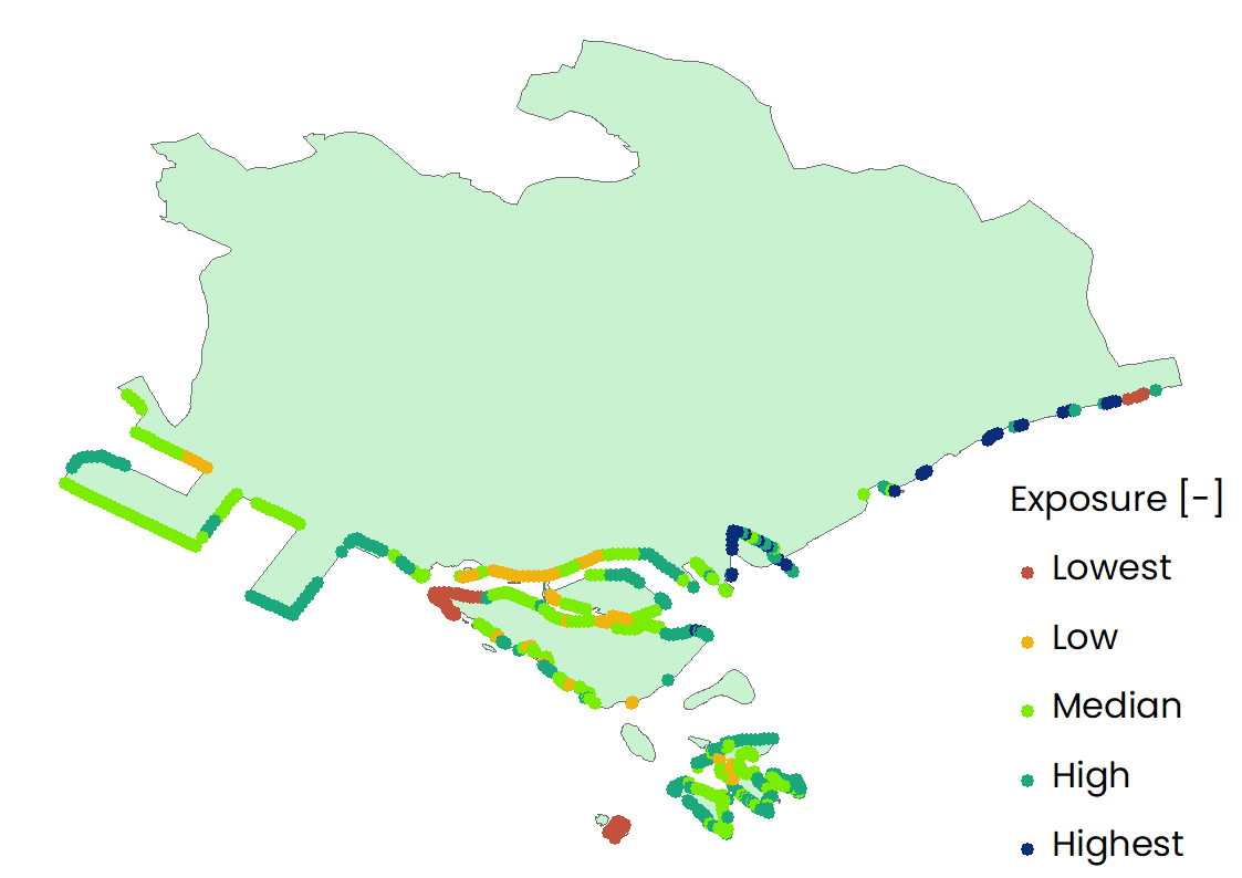 |
| Relative exposure to coastal hazard (no habitats, but with SLR) | 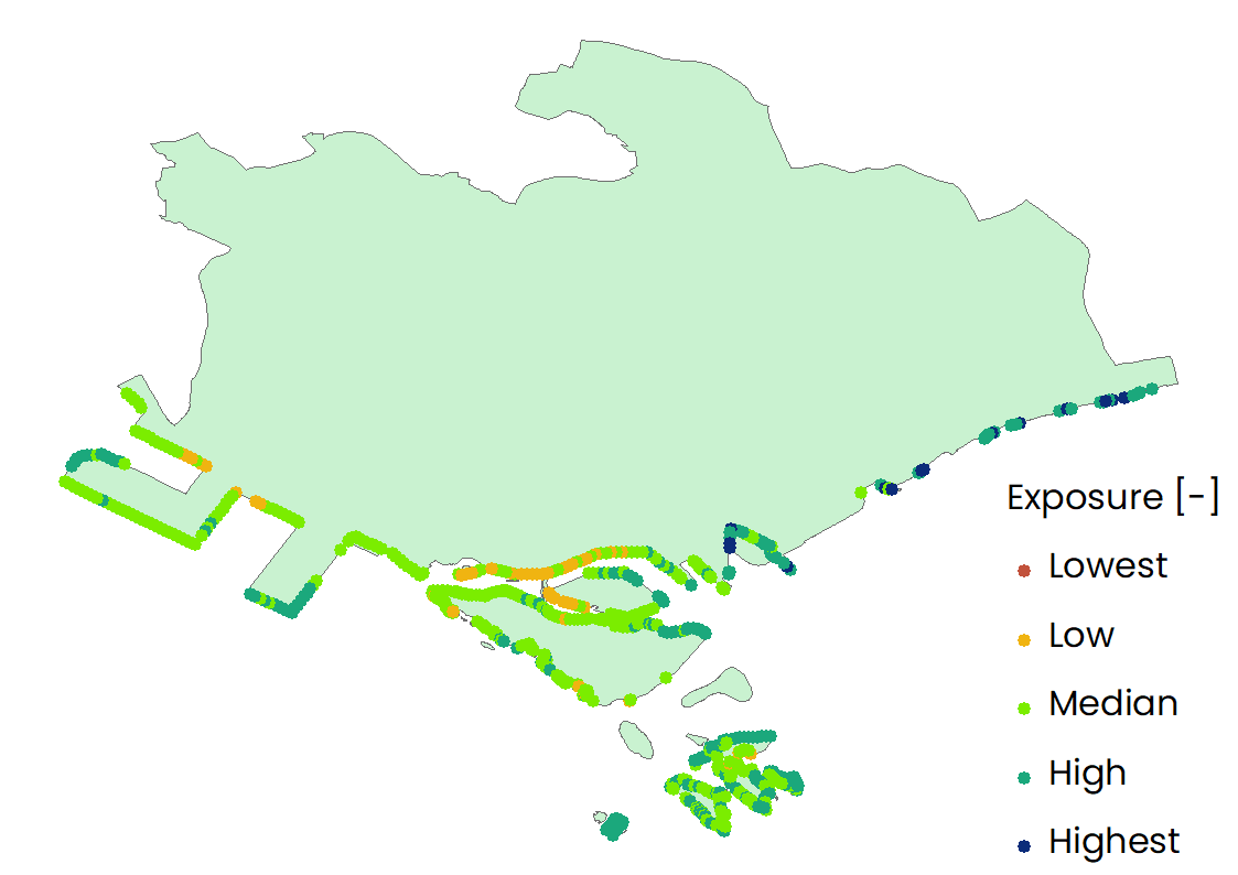 |
| Relative exposure to coastal hazard (no SLR, but with habitats) | 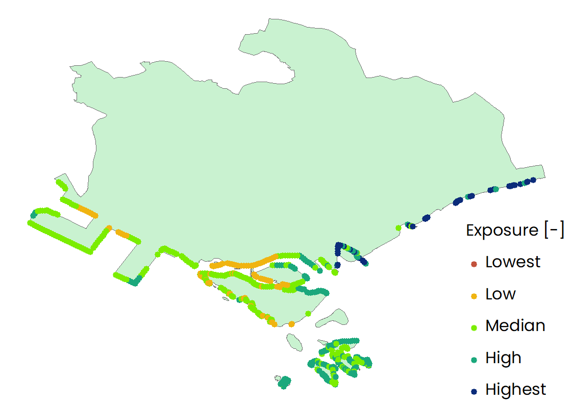 |
| Relative exposure to coastal hazard (with habitats and SLR) | 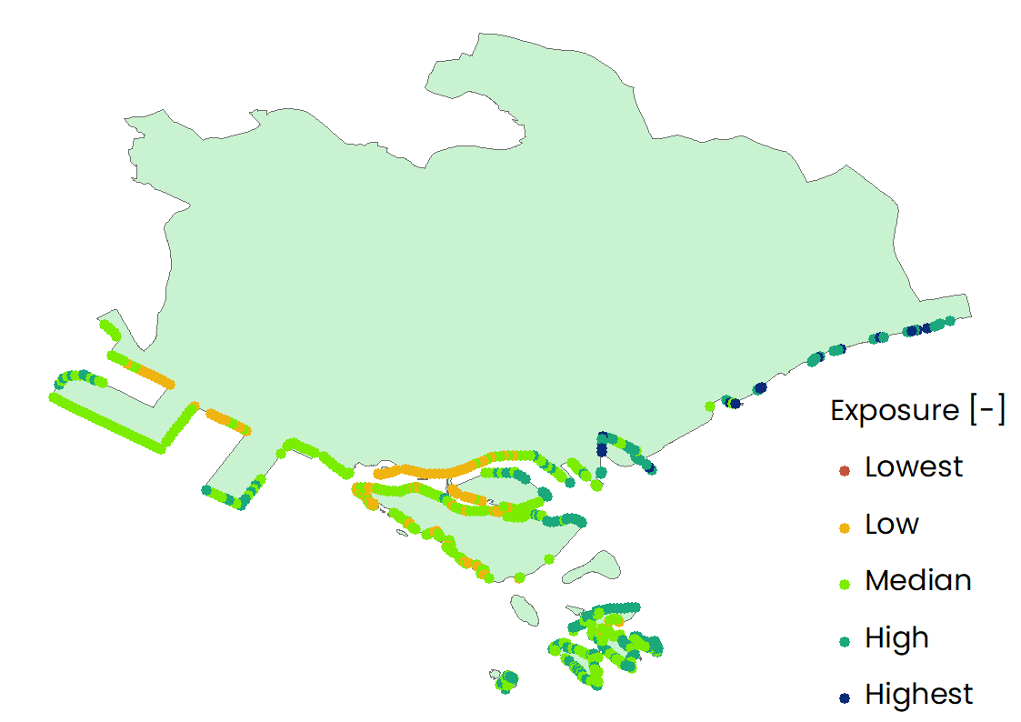 |